The geoglyphs of Nazca, commonly known as the Nazca Lines, have been a World Heritage Site since 1994. They are lines sometimes several kilometres long, geometric "drawings" and imposing figures up to 200 metres long, traced on the ground between the towns of Palpa and Nazca, 400 km south of Lima. Since their first discoveries in the 1930s, researchers have counted more and more of them every year. To date, there are some 360 in an area 450 km long.2.
Table of Contents

The geoglyphs are concentrated in the San José and Atarco pampas, a desert region on the south coast of Peru. "They also mark the mesetas (plateaux) of Palpa and the hillsides along the Rio de Nazca. The choice of these places is no accident. They are sacred places.explains Aïcha Bachir Bacha, archaeologist at the École des Hautes Études en Sciences Sociales. "The pampas are bordered to the north and south by rivers that join to form large tinkuy (1). The Rio Ingenio to the north and the Rio Nazca to the south join to form a large tinkuy, which marks the boundary of a sacred area inscribed with geoglyphs". (2)

These geoglyphs were drawn by moving the small dark-coloured ferrous stones that had accumulated on the surface of the desert to expose the underlying earth (light-coloured gypsum). They have been preserved relatively well for over 2,000 years, thanks to an almost total absence of rainfall and wind erosion. "The technique used by the Nazca to produce these drawings is both simple and ingenious: all they had to do was scrape the ground. All they had to do was scrape the soil, which consists of a dark, gravelly surface layer of much lighter clay. The dark, stony spoil was simply pushed back to either side of the route, where it formed a bank about thirty centimetres high. In addition to these intaglio drawings, there are some in relief and others, much older, incised into the mountainside", explains writer Parisina Malatesta in a Unesco letter devoted to Nazca (3).
Hundreds of designs

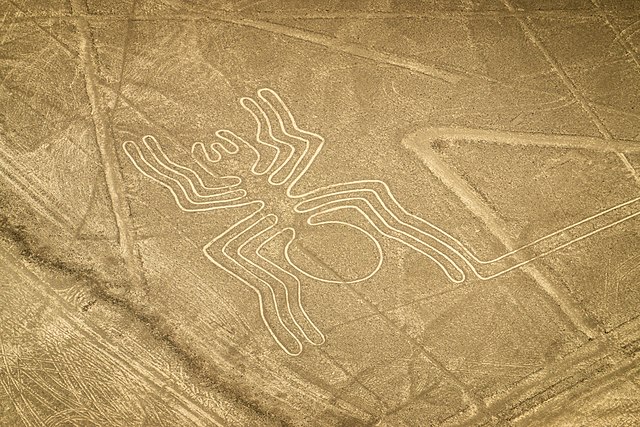
The glyphs are thought to have been created by the Nazca culture between 200 BC and 700 AD and also, in several cases, by their predecessors, the Paracas, farmers who lived in the same region between 800 BC and 200 AD.They include hundreds of individual figures, ranging from simple lines, trapezoids, spirals, etc. to animal representations (stylised hummingbird, spider, monkey, orca), plants or biomorphic figures (Biomorphic drawings are drawings of animals or plants, i.e. representing a biological species). Some of these representations These "lines" are also found on ceramics and textiles attributed to the ancient Nazca (50 BC - 350 AD). It is therefore accepted that the figurative geoglyphs are older than the lines. The latter have been assigned to the Middle Nazca (350-450 AD) and the Late Nazca (450-650 AD)".explains Aïcha Bachir Bacha.

Hardly visible to the naked eye from the ground because of their gigantic size, and also because erosion erases some of them over the years, these signs - some of which are visible from the hills - were mentioned as early as the 16th century by the Spanish chronicler and conquistador Cieza de Leon in his book "Crónicas del Perú.
Manuel Toribio Mejía Xesspe (1896-1983), a Peruvian archaeologist, was the first to study the lines in 1926. But it was not until the 1930s, when the first military pilots flew over Peru, that the public became aware of them. According to Toribio Mejía Xesspe, the lines correspond to a system of sacred paths used during ceremonies and processions. And his hypothesis is far from fanciful.
Baroque and fanciful interpretations

Numerous theories have been put forward to make sense of these mysterious lines, some of them rather exotic: solar calendars, sacrificial sites, means of communication with extraterrestrials or landing strips for spaceships, etc.
The American historian Paul Kosok (1869-1959), first thought in 1939 that they were part of an irrigation system, but then put forward another hypothesis: he observed the lines from a plane on 22 June 1941, the day after the winter solstice, and noticed that the setting sun was directly aligned with a long line. This is how the professor came to nickname this strip of desert the "the world's largest astronomy book and hypothesises that these lines were drawn for astronomical purposes.
Maria Reiche (1903-1998), a German-born mathematician and archaeologist, continued Kosok's work. She devoted her life to studying the site and lobbying for its preservation. In her words, "ancient peoples drew geoglyphs of the constellations most closely associated with water". and concluded that it was an immense astronomical calendar and that some of the animal sketches were inspired by groupings of stars in the night sky. However, in 1967, the British astronomer Gerald Stanley Hawkins (1928-2003), known for his work in archaeoastronomy, notably on the Stonehenge alignments, studied these lines with the help of a computer. He found no correlation between the changes in the celestial bodies and the drawings of the Nazca lines.
A religious explanation?

According to other researchers such as Maria Rostworowski, (1915-2016), a Peruvian ethno-historian specialising in the history of the Inca Empire, the large figures were designed to be seen from the air, and were no doubt intended for the public. god Konthe main deity of the Paracas and Nazca. Myths tell of this god's ability to fly, as can be seen on Nazca ceramics and textiles, where he is depicted.
Johan Reinhardanthropologist and National Geographic explorer, also gives a religious interpretation. "Most of the lines are probably not directed towards a point on the geographical or celestial horizon, but rather towards places where rituals were performed to ask for rain and good harvests".he writes in his book The Nazca Lines: A New Perspective on their Origin and Meanings.
AI to the rescue

TheYamagata University, Japanand Peruvian archaeologist Jorge Olano have been working since 2004 to catalogue the monumental geoglyphs of Nazca. Led by Professor Masato Sakai, archaeologists have conducted fieldwork to study the distribution of geoglyphs using satellite imagery, aerial photography, airborne scanning LiDAR, and drone photography. In 2022, they discovered 168 new geoglyphs representing humans, cats, orcas, birds, camelids, and snakes, and a «pair of legs» geoglyph, the largest of the Nazca geoglyphs discovered with the new artificial intelligence system. The joint study by the Nazca Research Institute of Yamagata University and IBM Japan, Ltd. was published in the international academic journal «Journal of Archaeological Science». (4)

According to Masato Sakai, the glyphs are in fact of two different types. The team has identified two distinct types of figure. The first are larger and have the shape of animals. At these sites, they found broken pottery, which led them to believe that these were ritual and ceremonial areas. The second group of figures is smaller and found near paths or on slopes. These geoglyphs are visible at ground level, whereas the larger figures can only be seen in their entirety from above. Because of their location, the researchers determined that they were probably trail markers or landmarks.
With the help of AI, the researchers plan to create a vast map of the geoglyphs of the Nazca and Pampa deserts. In collaboration with the Peruvian Ministry of Culture, this new information will help to protect these important heritage sites from future construction projects linked to the expansion of urban areas. The success of artificial intelligence technology is also opening up new prospects for archaeological research in the region. The discovery and preservation of these ancient wonders will provide a better understanding of these forms and the people who carved them.
So it seems that there are many more glyphs in existence than previously thought. With new technological means at our disposal, there is no doubt that our understanding of the Nazca lines will continue to evolve.
What are the risks of erosion and/or destruction for the Nazca geoglyphs?

The Nazca geoglyphs have generally remained intact over the millennia because of the arid climate. In fact, the scarcity of rainfall limits erosion and vegetation cover, but it is not enough. "Generally dry torrents can sometimes flow over the surface of this plateau during particularly vigorous el Niño events and erode it slightly". as explained in this article (https://planet-terre.ens-lyon.fr/ressource/Img659-2019-12-09.xml). In some places "Some stream beds intersect and erase the geoglyphs, in particular the temporary streams whose beds are lined with light-coloured pebbles and sand. Enough water has flowed through these few beds over the last 2000 years to locally erase-erode-recover the geoglyphs". In 2009, for example, heavy downpours from the Pan-American Highway - a major motorway linking almost every country in the Americas to the Pacific coast and passing through the Nazca area - deposited sand and clay on three fingers of the hand-shaped geoglyph.
What's more, this motorway is not equipped with railings or barriers to protect the lines from human destruction. As well as the damage caused by pollution from exhaust fumes, there is also the damage caused by careless or indiscreet drivers, those who use the excuse of a "mechanical emergency", as the driver of a lorry who recently destroyed one of the images did. Or those who unload their rubbish in this area along the Pan-American Highway. It's impossible to monitor everything on such a large site, and the few warning signs are not enough. Not to mention the illegal gold miners who use dynamite!
- Tinkuy in Quechua means a meeting, a union of two things, of two beings, but also a ritual combat.
- https://archam.cnrs.fr/les-geoglyphes-de-nazca-une-symbolique-inscrite-dans-le-desert-peruvien/
- https://unesdoc.unesco.org/ark:/48223/pf0000111124_fre
- https://www.sciencedirect.com/science/article/pii/S0305440323000559?via%3Dihub
See the interview with Peruvian archaeologist Jorge Olano https://universvoyage.com/jorge-olano-un-archeologue-a-nazca/
Text : Brigitte Postel
Opening photo : Spider geoglyph © Psamathe/Commons
For more information: https://www.peru.travel/fr